

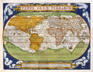
1st map of the world printed in an atlas.
This map published by Abraham Ortelius shows the mythical NW passage which was the purpose of Captain Cook’s 3rd and final voyage when he first discovered Hawaii. It also shows Terra Australias incognita “ Great Southern unknown land”.
Some European scientists at this time felt this land mass explained why the world sat upright.
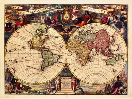
This decorative maps shows the voids in the World map prior to Captain Cook’s 1st Voyage. These included an uncharted east coast of Australia, New Guinea attached,
New Zealand uncharted, a blank Pac. N.W , Terra Australias and California as an island. Captain Cook would map most of these areas on his 1st Voyage to the Pacific in 1768.
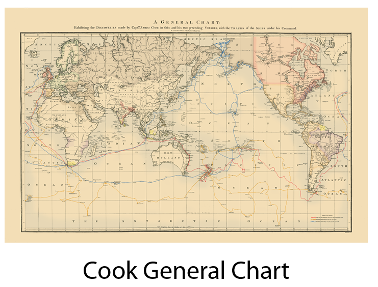
Cook’s General Chart of the Pacific published in 1784 is the first complete map of the world.
The Three Voyages of Capt. Cook (1768-1779)
Many Important discoveries in the Pacific
The first great map to identify what were called the “New Discoveries” was Capt. James Cook’s huge General Chart, published London in 1784 as part of his great third voyage atlas. Most people know Cook’s name, but what they don’t usually realize is how much of the Pacific was first charted by this English navigator during his three famous 18th-century expeditions.
In three voyages from 1768 – 1779, Cook traversed vast expanses of the Pacific Ocean and made many important discoveries.
He was the first to circumnavigate New Zealand and show it as two separate islands, the first to sail far into the Antarctic region and dispel the idea of a great southern continent. He was the first to map Australia’s coastline. He penetrated farther into the North Pacific looking for a Northwest Passage and mapped more of this region than any other explorer of his era. Perhaps his most significant finding was to reliably locate and map the Hawaiian chain which had been missed by many earlier navigators in the Pacific.
A Key to the Coloring on the Map
Cook’s famous chart of the Pacific was published in England in 1784 as a part of the 3rd Voyage Atlas. It was issued uncolored as a copperplate engraving. It is shown here in a colored version. Lines illustrate the track of Cook’s ships -Red for the 1st voyage, yellow for the second, and blue for third. On land the Spanish Empire is colored orange, pink identifies the British Empire, while gray shows Russian lands. French territory is light green, Portuguese is purple and Dutch holdings are yellow.

Custom sizes available upon request. Please contact (808) 871-4547.
Complimentary Domestic Shipping on all prints
1st map of the world printed in an atlas.
This map published by Abraham Ortelius shows the mythical NW passage which was the purpose of Captain Cook’s 3rd and final voyage when he first discovered Hawaii. It also shows Terra Australias incognita “ Great Southern unknown land”.
Some European scientists at this time felt this land mass explained why the world sat upright.