This map combines the first printed map of Hawaii with the first recorded view of Europeans on the island of Hawaii. John Webber, the official artist , captured Captain Cook and his men in the only bay where Cook was to land on the Big island, where he eventually met his untimely demise.
The second European explorer to visit Hawaii and the first to come ashore on the island of Maui was the French explorer Jean Francois La Perouse.
La Perouse visited Hawaii and oversaw the compilation of this chart published in 1797. His extremely short stay, however, precluded his hydrographer, Bernizet, from completing the charting of shorelines which were missed during Cook’s voyage.
La Perouse touched only at the island of Maui, consequently most of this map was taken from Roberts’ earlier chart of Hawaii. Bernizet’s miscalculation of the east – west distance for the Big Island and a new mapping of the south coast of Maui are the two significant improvements this explorer put on the map from his brief 48 hour visit.
The third major expedition to Hawaii was led by the English explorer Capt. George Vancouver, who visited the islands between 1792 and 1794. He had traveled to the Pacific with Capt. Cook on both the 2nd and 3rd voyages. Vancouver was one of the most qualified and experienced English officers. He sailed to the Pacific with the specific purpose of settling a dispute in Nootka Sound and finishing what Cook had started …searching for the elusive Northwest Passage.
His was the only expedition to completely circumnavigate all the islands of the chain. Vancouver’s voyage resulted in the first published map of Hawaii depicting the islands in their entirety. This landmark work, credited to Joseph Baker, is one of the most significant maps in Hawaiian history.
The Vancouver - Baker chart remained the basic map of Hawai‘i for nearly 80 years, though some of the errors found were corrected by later map makers.
Additionally, Vancouver introduced cattle to Hawaii and is responsible for a political relationship between Hawaii and England which led the Kingdom of Hawaii to make its own flag and to insert the Union Jack in the upper corner. Hawaii was never under British rule, though it was for some years a British protectorate.
This 18th century Italian map is notable for its decorative and fanciful cartouche depicting the “Death of Cook” in a highly unusual scene showing native who seem to be dressed as American Indians stabbing him
An early Italian Map of the islands: Fanciful but Pretty
Published in 1798, one of the first decorative maps of early Hawai‘i is “Le Isole di Sandwich,” by Giovanni Cassini. The map is based on Cook’s chart however, Cassini, inspired by John Webber’s engraving, added his version of the Death of Cook to the cartouche.
Because the artist had little knowledge of Polynesians or English officers’ uniforms, he used his imagination and placed Cook’s men in Italian officers’ uniforms and depicted a warlike band of Indians (who appear to be much like Native Americans) in feathered headdress. They are shown stabbing the good captain in the back.
This map clearly shows the phonetic spelling used by Captain Cook when attempting to spell the names of the islands.
One of the first maps made in Hawaii, in Hawaiian by a native Hawaiian engraver who had learned his craft from American missionaries. It was published in 1838.
This Pacific centered double hemisphere map was produced at Lahainaluna on the island of Maui by Hawaiian students. The diagram on the right of the map shows the relative heights of major mountains.
Missionary Map Shows Hawaii in the Center of the World
Several students at the school did the actual drawing and engraving of the maps. Two of the most prolific were Kalama and Kapeau. Kalama later became one of the best surveyors in the islands, and Kapeau eventually became Governor of the island of Hawaii. A young boy who was not a student, Kepohoni (his name is the Hawaiian word for Cape Horn) did the largest number.
The maps were essentially copies of maps from popular school atlases. Since they were intended for the use of the Hawaiian students, the place names were given either in the Hawaiian form of the name or in a modified transcription in which vowels were added so the foreign words could be pronounced in the Hawaiian style.
This Hawaiian language version of double hemisphere world map was engraved to aid Hawaiian students in learning global geography. It represents a joint effort by Kalama and Kepohoni. Several students at the Lahainaluna did the actual drawing and engraving of the maps. This map offers a rare Pacific centric world view placing Hawaii in the middle of the map. Most school maps of this period focused on the Atlantic Ocean and showed Hawaii as a tiny dot far off to the side.
The U.S. Exploring Expedition, Lt. Charles Wilkes 1840 - 1841
Large-scale scientific investigation in Hawaii began with the visit of the United States Exploring Expedition in 1840. This expedition, which also visited many other parts of the Pacific, was under the command of Lt. Charles Wilkes. Among its many firsts, this expedition was the first overseas scientific project financed by the US government.
Its accomplishments were numerous, including the first extensive mapping of the Antarctic coastline, the first comprehensive charting of Fiji Islands, volcanic studies in Hawaii and elsewhere in the Pacific, and extensive survey work in the area of present-day Oregon and Washington.
Another major accomplishment from this expedition was the first mapping of the Hawaii volcanoes, including the summit of Mauna Loa, the crater of Kilauea on the Big Island and Haleakala on Maui.
The results of the U.S. Ex. Ex. were published in five-volumes. The narrative was written by Wilkes; the technical reports were done by scientists who accompanied the expedition. The botanical, zoological, and marine specimens brought back by the expedition formed the basic collections of the newly established Smithsonian Institution.
Hiram Bingham was one of the early Christian missionaries to Hawaii. The task of teaching industry and Christian values to the Hawaiians was a big one, and so Bingham sent for reinforcements who arrived in the form of the newlyweds Rev. and Mrs. Sheldon Dibble.
During Dibble’s Hawaii tenure, he taught at the missionary school in Lahainaluna on Maui. He played a key role in recording and saving the oral history of Hawaii. He was the author of the first written history, “A History of the Sandwich Islands,” in 1834, which included the Lahainaluna map, engraved and printed by Dibble’s students from copper sheeting. The maps printed at Lahainaluna were some of the first maps of Hawaii to be printed in Hawaii by Hawaiians.
Hiram Bingham and his wife arrived on the Island of Hawaii in 1820 and then sailed on to Honolulu. Bingham played a key role in the translating and creation of the spelling system for the Hawaiian language. He also translated several books of the Bible into Hawaiian.His memoir “A Residence of Twenty-One Years in the Sandwich Islands” was published in which this detailed wood block map appeared. The map was one of the first to show the island names spelled utilizing the missionary inspired 12 letter alphabet.
Shows a Pacific centered view of Hawaii, as well as its flag.
The first major map published by the Hawaiian Government Survey was prepared especially for the Hawaiian exhibit at the International Exhibition of Arts, Manufactures and Products of the Soil and Mine, which opened in Philadelphia in the spring of 1876, celebrating the 100th anniversary of American independence, it was more commonly known as the Centennial Exhibition.
In size, design, and execution it compared favorably with the best wall maps displayed there. Its design and scope were undoubtedly decided by Surveyor General, W.D. Alexander, with the manuscript compiled by Curtis Lyons, who was responsible for most of the drafting for the government survey at that time. H.Giles is credited with the final execution.
At a scale of 30,000 feet to the inch, the map said Alexander, “will do this country no little credit at the Centennial.” Alexander also noted that the map was an impressive four feet high by six feet wide. As it turned out, however, the printed map was published at approximately thirty-five inches in height by fifty-five inches in width, or 75 percent of the actual size Alexander had intended, a reduction that may have been made for reasons of cost or expediency. Certainly publishing a map at the intended size would have been a monumental task; even at the final size it was a significantly large map for the time period.
The change in size also changed the scale, from 30,000 feet to the inch, or 1:360,000 to 40,000 feet to the inch, or 1:480,000. Regrettably, when the scale statement was printed, it kept Alexander’s planned scale of 30,000 feet to the inch rather than showing the actual scale. Such an error would have been difficult to catch without having a representative of the Hawaiian Government Survey in attendance at the printer’s plant. As the agency’s first formal production, the map remains a remarkable achievement despite the error.
An examination of the Centennial map reveals that it deliberately departs from the policy and intent of the Hawaiian Government Survey. Unlike the agency’s other maps, it is not a map of the landed property of the kingdom and was not meant for a technical audience.
Alexander thus chose to highlight the main topographical features rather than information on land titles or land divisions. Those features are more accurately placed than ever before, and the kingdom’s towns and major plantations and ranches are named.
Alexander took extra pains to portray information not normally found on a map of this type, by indicating the extent of many of the major forested areas on Hawaii and Maui and delineating historic lava flows. However, at this stage in the life of the government survey, only Oahu had been completely surveyed and was thus correctly drawn. In the coming years, the agency would improve the shape of the individual islands as accurate surveys were completed, but the Centennial map remained the basic map of the Kingdom until 1901.
The map’s design contained a number of interesting aspects, the compass cartouche, for instance, appears to link Hawai’i with the American mainland. Considering the map’s debut at a centennial celebration for the United States, one might wonder if this placement was intentional. Also notable are the insets in the lower left corner of plan views of Haleakala, Moku’aweoweo, and Kilauea. Since the map held a prominent place in the Hawai’i exhibit at the exposition, the inclusion of these craters reflects the pride Hawaiians took in their volcanoes.
By highlighting volcanoes and lava flows, the kingdom may have been playing to the nascent tourist industry. It is interesting to note, for example, that all the crater plans are drawn at the same scale of approximately one mile to the inch. On either side of the map’s title is a representation of the main building of the exposition drawn at the same scale. At more than a quarter mile long, the exposition building was monumental for its time. The judicious placement of the crater insets seems almost a subtle taunt from across the Pacific; “If you think this building is grand you should see our volcanoes”
1st Map of Maui printed by the Hawaiian Government
Maps of Individual Islands Ongoing
Frank S. Dodge started the task of completing and assembling Maui surveys into a general map of the island in 1879 and finished late in 1885, following completion of survey work on West Maui that was done in large part by Sereno E. Bishop. The map was sent to Julius Bien in New York, who printed five hundred copies in the spring of 1886. The map shows the ancient districts, or moku, which have since been realigned on Maui, as well as the ahupua’a and the ili, along with the grants and awards by which they were held.
In addition to the standard colors of yellow for Crown land green for government lands, Dodge employed several other colors to cope with the land complexities of Maui. For example, an unusual land in Hawaii is the ili kupono of Wailuku, shown in pink and covering the north half of the isthmus that connects the two halves of the island. An ili kupono was an ili that was independent of any ahupua’a. Wailuku was purchased by Claus Spreckels in 1882 and formed a major component of his sugar empire in Hawaii.
Dodge’s map of Maui, like the Lyons - Covington map ofOahu is a tribute to the skill and dedication of the staff of the Hawaiian Government Survey. Two sections of this map are worth examining in detail. The northeastern portion of East Maui, famed for its twisting road that makes even hardy travelers of today carsick, is one of the most rugged pieces of land anywhere in the United States. Its deeply incised, steeply falling valleys are difficult passage for the strongest of hikers. Yet by 1883 the courses of most of the streams and the ridges separating
Philadelphia publishers Linton & Garragues issued this map in February 1893 one month after the overthrow of the Hawaiian Monarchy. Signed by some of the leading men in the take over it contained an inflammatory text depicting the native people as heathens and baby eaters. It also shows the arrows seeming to place Hawaii at the hub of the Pacific.
CUSTOM SIZES AVAILABLE UPON REQUEST. PLEASE CONTACT (808) 871-4547.
Complimentary Domestic Shipping on all prints
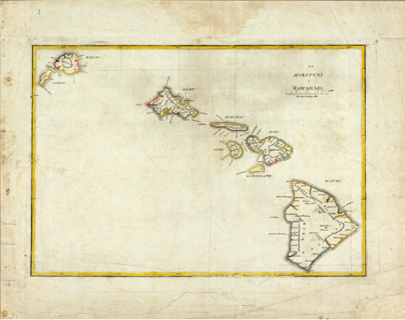
The First Printed Map of Hawai’i
The first map of Hawai’i is often credited to Captain James Cook because he was in charge of the expedition that produced it. The official map is attributed to Lieutenant Henry Roberts, who prepared for publication all of the maps appearing in the three-volume narrative detailing the adventures of Cook’s final voyage.
The large inset of “Karakakooa Bay” represents Kealakekua Bay on the island of Hawai’i, where Cook spent several weeks before dying in a clash with the Hawaiians on February 14, 1779. The tracks of Cook’s ships are shown by the dashed and solid lines. The longitudes in the bottom and top borders are numbered continuously in an eastward direction from Greenwich; the longitudes shown on this map can be converted to the modern format by subtracting the value of 360.
Although best known for his involvement in the famous mutiny on the Bounty, Bligh was an outstanding seaman and accomplished chartmaker. Only twenty-one when selected by Cook as master for his flagship, the Resolution, Bligh performed many critical duties aboard ship, one of which was to assist in the making of the charts and harbor plans. After the publication of the official narrative of Cook’s third voyage, Bligh privately challenged the assertion that Roberts drew the maps that accompanied the volumes, claiming credit himself for many of the maps, particularly the plan of Kealakekua Bay and much of the larger map of the “Sandwich Islands.”
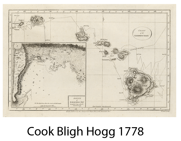
This is a later edition published by Alexander Hogg in 1795. The official 1st edition was published in 1784 by Strahan & Cadell. The circle around the title is unique to the Hogg edition.
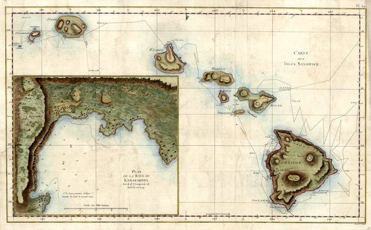