Featured


The rise of tourism in the Islands prior to World War II spurred another kind of map making. These were mainly decorative, illustrated maps created for souvenirs. Printed in many colorful styles, they were often issued by hotels, shipping lines or private companies and helped to popularize knowledge of the islands. Very popular were the series of cartoon maps by Ruth Taylor White. Stylized views published by Dole Pineapple were also graphically appealing. Many maps from these years bear the initials “T.H.”, for Territory of Hawaii.
This 18th century Italian map is notable for its decorative and fanciful cartouche depicting the “Death of Cook” in a highly unusual scene showing native who seem to be dressed as American Indians stabbing him
An early Italian Map of the islands: Fanciful but Pretty
Published in 1798, one of the first decorative maps of early Hawai‘i is “Le Isole di Sandwich,” by Giovanni Cassini. The map is based on Cook’s chart however, Cassini, inspired by John Webber’s engraving, added his version of the Death of Cook to the cartouche.
Because the artist had little knowledge of Polynesians or English officers’ uniforms, he used his imagination and placed Cook’s men in Italian officers’ uniforms and depicted a warlike band of Indians (who appear to be much like Native Americans) in feathered headdress. They are shown stabbing the good captain in the back.
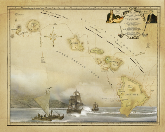
This map clearly shows the phonetic spelling used by Captain Cook when attempting to spell the names of the islands.
FEATURING ARTWORK: NANTUCKET SLEIGH RIDE
Hiram Bingham was one of the early Christian missionaries to Hawaii. The task of teaching industry and Christian values to the Hawaiians was a big one, and so Bingham sent for reinforcements who arrived in the form of the newlyweds Rev. and Mrs. Sheldon Dibble.
During Dibble’s Hawaii tenure, he taught at the missionary school in Lahainaluna on Maui. He played a key role in recording and saving the oral history of Hawaii. He was the author of the first written history, “A History of the Sandwich Islands,” in 1834, which included the Lahainaluna map, engraved and printed by Dibble’s students from copper sheeting. The maps printed at Lahainaluna were some of the first maps of Hawaii to be printed in Hawaii by Hawaiians.
FEATURING ARTWORK BY CHARLES MORGAN
This map combines the first printed map of Hawaii with the first recorded view of Europeans on the island of Hawaii. John Webber, the official artist , captured Captain Cook and his men in the only bay where Cook was to land on the Big island, where he eventually met his untimely demise.